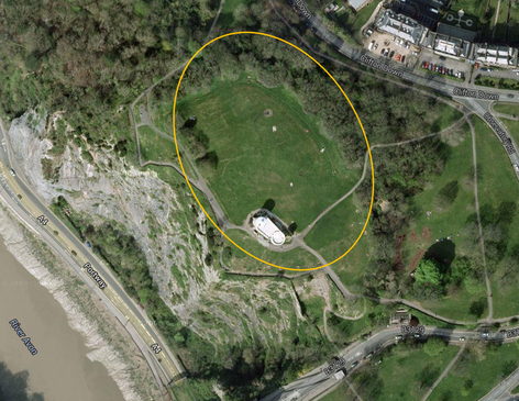
 Approximate area of the Iron Age Hill Fort © Google
 On a still and slightly foggy morning
... I’m trying to create an atmosphere …
I tagged along with Gail and Zac to the Iron Age Hill Fort on Clifton Down (where the observatory is) to observe a drone demonstration.
With our risk assessment and our sensible shoes we carefully walked along the paths to the Iron Age Hill Fort and met up with our Drone Operator Stephen.
Before I go any further I want to point out that drones are being increasingly used archaeology. Unlike the drones used by military organisations, archaeology drones have emerged through radio controlled hobbyist models and are tools used for aerial photography, regional surveys, site identification, mapping, 3D modelling and creating virtual reality environments.
They have been used with great success in Peru to map sites from the 1300 year old Moche civilization (they pre-date the Incas). The ruins of the Moche cities have deteriorated so much that they can hardly be seen anymore, but, the aerial photographs can be made into a maps and 3D models. These techniques mean that the layout of the cities can be seen for the first time in centuries.
So back to our demonstration…
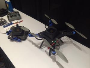
An archaeology drone created using a 3D printer by Arch Aerial (http://archaerial.com/)
After Stephen checked that the drone had the correct flight programme loaded and that the flight programme was not going to direct the drone to crash into the observatory or a nearby tree, we were nearly ready to go. Stephen told us that the his drone can fly to 2km above the ground but we only needed it to be about 40m above the ground. After one final check to ensure that no passers-by would wander under the flight path, we launched the drone! The drone
has propellers so it more gracefully rose from the ground than being launched like a rocket into the sky – but still really cool to watch!
So we observed as the drone hovered about 40m off the ground moved about taking approximately 150 photographs. I was amazed at how quick this was done – up and down in 3minutes!
As the flight programme is loaded onto the drone, it can pretty much fly itself so there are many, many possibilities for this technology to be used in, for example, community archaeology projects. I think that the technology will show that archaeology is becoming increasingly tech-savvy and this will appeal to more young people, some of whom see us a brightly dressed bumble bees crawling around the ground with a trowel! There is also the possibility of
creating virtual reality environments and 3D models of ancient and scheduled monuments and hill forts. There is the potential that these virtual reality environments and 3D models can be used to enhance the Prehistoric Period
Learning workshops at Bristol Museums, Galleries & Archives…
 RSS Feed